(do you want to know more ?)

|
Save CareFlight (do you want to know more ?) |
|
|
Bikes Giant VT1 |
Lights
50W+20W Mk1 
|
Missed Shifts
The Bobcat breaks 70kph! Just what is a Night Monkey Daily Commuter Diary |
Nav-aids
|
OnLine Shops | Great Links |
|
Dirt Rides Information on rides, mostly in the Northern Sydney region. Most of the rides here are suitable for night time and/or novices. DISCLAIMER - Just because the ride is still listed does NOT mean it's still legal !!! DISCLAIMER - maps, profiles and track logs are indicative only. DISCLAIMER - profiles and coordinates are NOT guaranteed to be accurate. DISCLAIMER - Ride within your limits - Respect other trail users and uses. |
| NAME | Location | dist/time | Surface | MAP(s) | Sat Image | Tracklog (txt) | Profile | Comments |
| Garrigal in general | Belrose, Davidson, St Ives | 10km ~1hr | FR | map | image | log | profile | A Great little GEM ! |
| Garrigal Hills cct | Belrose, Davidson, St Ives | 13Km ~1hr | FRS | map | image | log | profile | Ride Anti-clockwise for biggest hills ! |
| Garrigal and Oxford Falls Big-Loop |
Belrose, Davidson, St Ives, Oxford Falls | 23Km ~1.5-2hr | FRS |
Part 1 jpg Part 2 jpg Part 3 jpg map |
image | log | profile | Extension required. Try adding Cambourne tracks. |
| Garrigal and Oxford Falls 30km |
Belrose, Davidson, St Ives, Oxford Falls | 30Km ~ 2-3hr | FRS | map | image | log | profile | 30km road, trail and s.track plus 8-10 significant hills |
| Oxford Falls XCCT | Oxford Falls | dist | FS | map | image | log | profile | link to Description and photos |
| Road to SomeWhere | Oxford Falls | dist | S | map | image | log | profile | link to Description and photos |
| Little Moab | Oxford Falls | dist | S | map | image | log | profile | link to Description and photos |
| DownHill Course | Oxford Falls | dist | D | map | image | log | profile | link to Description and photos |
| Lizard Rock | Oxford Falls | dist | XDS | map | image | log | profile | link to Description and photos |
| Red Hill | Oxford Falls | dist | FS | map | image | log | profile | link to Description and photos |
| Perimiter Track | Terry Hills | dist | FR | map | image | log | profile | link to Description and photos |
| Ryland Track | Terry Hills | dist | F | map | image | log | profile | link to Description and photos |
| ShowGround Loop | St Ives + Terry Hills |
35km | FSR | map | image | log | profile | link to Description and photos |
| Manly Warringah BMX | Terry Hills | dist | cct | Google Earth | image | log | profile | link to Description and photos |
| Center Track | Terry Hills | dist | FR | map | image | log | profile | link to Description and photos |
| Smiths Ck | Terry Hills | dist | FRS | map | image | log | profile | link to Description and photos |
| Salvation Loop | West Head | dist | FR | map | image | log | profile | Includes Center Track |
| Warratah track | West Head | dist | FR | map | image | log | profile | Includes Center Track |
| Center Track Salvation Loop Challenger Track West Head |
TerryHills WestHead [Google Earth] |
40km | R(F) | map | Sat image | PLT log | profile round trip |
A great fast ride with a couple of hills |
| Lane Cove Valley | Ryde | 9 km | FRS | map | image | log | profile | link to Description and photos |
| Twin Creeks | Roseville | 10km rtn ~ 1hr | FS | map | image | log | profile | link to Description and photos |
| Manly Dam | Manly/Seaforth | 12km | FRS | map | image | log | profile | link to Description and photos |
| Manly Dam and more | F'Forest/Seaforth | 20km | FRS | no map | image | log | profile | link to Description and photos |
| Sydney Bridges, Balmain to Nth Sydney |
Balmain thanks to Terry & Linda |
30km | R | map PDF | JPG image KMZ |
eXplorist PLT Log as TXT |
profile | Great night lights ! |
| Prospect Resevoir, Orphan School Ck |
Western Sydney thanks to Terry & Linda |
35km | Cycleway | Prospect Resevoir - Orphan Ck at EveryTrail Map created by EveryTrail:Share GPS tracks | Map.pdf | log | no profile | View the Photo Proof Sheet |
| Wisemans BIG loop | Wisemans Ferry | ~95km ~9hrs | FR | MAP Part4 Part3 Part2 Part1 |
SAT JPG KMZ |
Log DMX (txt) PLT |
Profile |
Description and photos |
| Wisemans Pub to Pub | Wisemans Ferry - St Albans | 40km ~2-3hrs | R | MAP JPG |
SAT JPG |
Log TXT |
Profile JPG |
link to Description and photos |
| Wisemans Loop #2 | Convict Rd - Clares bdg - Donnies Track - Simpsons trk - Convict Rd |
50km ~6hrs April 2006 |
F(S)R | map |
image | log | profile | link to Description and photos |
| Simpson Track | Wisemans Ferry | dist | FR | map | image | log | profile | link to Description and photos |
| Eastern Commision Track | Wisemans Ferry | approx 70km | FR | map | image | log | profile | link to Description and photos |
| Western Commision Track loop | Wisemans Ferry | Dist | FR | map | image | log | profile | link to Description and photos |
| The Old Convict Road | Howes Valley-Wollombi-Wisemans | dist | FR | map | image | log | profile | link to Description and photos |
| Dirtworks Classic 2006 | StAlbans-Wisemans | 100km | FR | map1 map2 map3 |
image | log | profile | Some sections are on PRIVATE LAND and should NOT be ridden outside the event !! |
| Dirtworks Classic 2008 | Tony's YouTube | 50km | FR | Tony's YouTube Link | Some sections are on PRIVATE LAND and should NOT be ridden outside the event !! |
|||
| Yellowmundi XC track | Yarrumundee | 12km ?? | S | map | image | log | profile | link to Description and photos |
| The Oaks | Woodford - Glenbrook | dist | FR | map | image | log | profile | link to Description and photos |
| The Oaks + St Helena | Glenbrook to Glenbrook and back again |
dist | FR | map | image | log | profile | Movie (2Mb WMV) |
| The Andersons | Wentworth Falls - Glenbrook | 50 km | FR | map | image | log | profile | link to Description and photos |
| Narrow Neck | Katoombah | dist | FR | map | image | log | profile | link to Description and photos |
| Kangaroo Valley Ride | Kangaroo Valley | dist day | FR | map | image | log | profile |
View the Photo Proof Sheet or Interactive Slide viewer |
| Full Fling 2005 Highland Fling 2005 |
Bundanoon + Wingello | 100Km | FRS | map | image | log | profile | link to Description and photos |
| Full Fling 2006 Highland Fling 2006 |
Bundanoon + Wingello | 104Km | FRS |
View the Interactive Slide viewer or the entire Photo Proof Sheet |
||||
| Full Fling 2007 Highland Fling 2007 |
Bundanoon + Wingello | 110Km | FRS |
View the Interactive Slide viewer or the entire Photo Proof Sheet |
||||
| Full Fling 2008 Highland Fling 2008 |
Bundanoon + Wingello | 110Km | FRS |
View the Interactive Slide viewer or the entire Photo Proof Sheet |
||||
| Urban Polaris 2006 another fantastic Wild Horizons event |
Canberra ACT
|
You choose! | FRS |
Snap Shots We made the ABC news (Windows Media) Urban Polaris Wrap-up Check out other Wild Horizons events |
||||
| Arcadia XC track | Arcadia MWMTB club track |
dist | S | map | image | log | profile | link to Description and photos |
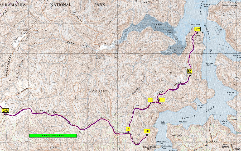
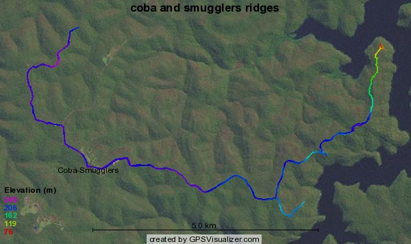
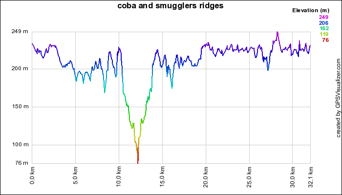
| Smugglers and Cobar Ridges courtesy of Terry and Linda |
Marramurra | dist | F | MAP map1 map2 |
SAT image KMZ |
Log PLT |
Profile JPG |
link to Description and Photos |
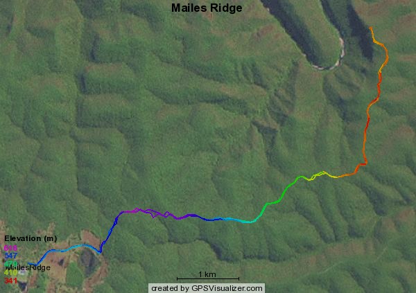
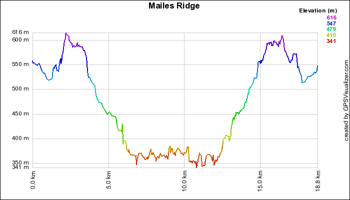
| Mailes Ridge - Maountain Lagoon courtesy of Terry and Linda |
Mountain Lagoon | 20km ret | F | MAP map1 |
SAT image KMZ |
Log PLT |
Profile JPG |
link to Description and Photo |
| Mt Canobolas | Orange | dist | FR | map | image | log | profile | Description and photos |
| Charlotte Pass to Rawson Pass |
Kosciuszko | dist | F | map | image | log | profile | Lock bikes up at Rawson Pass and walk to sumit |
| England! | England | last 500 of 1300km | R | map | image | log | profile | Multi day ride |
.jpg)